
Analysis: Weld County is booming. That’s complicating its politics
By Trenton Sperry
Weld County could soon find itself cracked into three different congressional districts, according to the first preliminary map for congressional elections during the next decade.
The largest changes to Colorado’s congressional districts, in fact, center on Weld, where a population boom has upended decades of traditional political fault lines. Weld has remained a political “unit” in its entirety in congressional district boundaries since at least the 1970s -- and a solidly Republican unit, at that.
But with Colorado’s rapid growth over the past 10 years -- and with a requirement in the U.S. Constitution that congressional districts be redrawn every 10 years based on population data gathered by the U.S. Census -- a new, voter-approved, bipartisan commission in Colorado was required to draw in an additional eighth congressional district in the state.
Just where that district would go and how the seven other districts would change has been a big question for political gurus since last year. That is, until the commission’s announcement Wednesday.
Here’s the map the group stressed is still in the early stages -- and which will no doubt elicit strong reactions from interested groups and communities over the next few months.

One potential reason for uproar up here in Weld? The three districts could have consequences for down-ballot races like county commissioner.
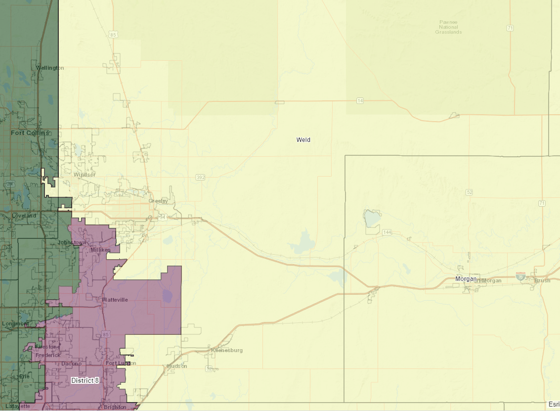
Under the map released Wednesday afternoon, the Weld communities of Johnstown, Mead and Erie (plus the little bit of Longmont in Weld County) would get pulled into the Second Congressional District, held by Boulder Democrat Joe Neguse since 2019.
Additionally, Milliken, Platteville, Firestone, Frederick, Dacono and Fort Lupton -- and some outlying Greeley and Evans areas -- would be pulled into the new Eighth Congressional District. This new district would have a heavy Front Range / north Denver suburb influence; it also would contain Westminster, Arvada, Thornton, Broomfield and Brighton.
The potential addition of a congressional district in this area highlights the region’s population growth over the past decade. For instance, Broomfield County grew by 26% from 2010 to 2019, according to population estimates from the U.S. Census Bureau. The city of Brighton grew by a similar 24% in that same time span, and Thornton grew by 19%.
The commission’s report notes this district would have a Democratic lean of about 7 percentage points, but that figure is a bit misleading. There would be about 140,000 registered Democrats in the district and about 107,000 registered Republicans, but those numbers are dwarfed by about 208,500 registered unaffiliated voters as of June 15. Unaffiliated voters in Colorado do tend to lean Democratic when it comes time to fill in a bubble on their ballots, but that certainly isn’t a given, especially in House races.
Plus, a new congressional district means a new opportunity for political hopefuls. That new opportunity likely will draw strong candidates from both parties, making an “average” lean of the district difficult to determine, at least for a few cycles.
Left in the Fourth Congressional District -- represented by Windsor Republican Ken Buck since 2015 -- with the Eastern Plains and southern Colorado (which would now have a huge Republican advantage of more than 20 percentage points) would be Greeley, Evans, Windsor, Severance, Lochbuie, Hudson, Keenesburg, and the remainder of Weld’s vast but sparsely populated areas.
But, wait, Greeley, Evans and Windsor are growing quickly, too -- by 17%, 15% and a staggering 63% over the past decade, respectively. Wouldn’t it make more sense for them to join a congressional district focused on the growing cities such as Westminster, Arvada, Thornton, Broomfield and Brighton, than say, the agricultural community of Platteville?
Maybe, but the commission has to balance a lot of motivations when it draws its maps, including cultural and economic history, the levels of minority groups, existing boundaries like county and municipal lines, and even physical boundaries like rivers and mountains.
Sure, the most important part of that equation is population, but even that aspect has multiple angles the commission has to consider.
Congressional districts in each state have to be virtually identical in population size. Because the Eastern Plains are sparsely populated compared to the Front Range, there was always going to be some relatively well-populated communities thrown together with the plains to bring each congressional district’s total population up to the same level as, say, downtown Denver (which has its own district under the new map, CD1).
Under this first -- and, it cannot be stressed enough, very preliminary -- map, those communities appear to be Greeley and Pueblo, plus a good portion of southern Colorado.
So, what’s next?
The commission will get reactions from community members and stakeholders all across the state, hoping to hear what they like or dislike about this map. Once that feedback cycle is complete -- and once the U.S. Census Bureau actually gets its data out to states -- the Colorado commission will give it another go, producing map after map and getting more feedback until it’s satisfied with a final version.

One group of stakeholders likely to voice disapproval of the newly released map will be the Board of Weld County Commissioners. Congressional maps tend to guide Colorado’s county commissioners as they draw their own boards’ boundaries. Weld has three commissioner seats elected by district boundaries and two seats elected at-large.
In its recently concluded session, the Colorado Legislature passed a bill that changes the way county governments can draw their districts, and the Weld commissioners signaled they don’t think the bill should apply to them, citing the county’s Home Rule charter.
Under Weld’s current map, Greeley -- the largest city in the county -- is split into all three commissioner districts, which breaks up its comparatively Democratic-leaning voting populace into small constituencies. The legislature’s bill -- and the guidance from the congressional map released Wednesday -- could put that practice in jeopardy, giving Democrats a better shot at a board seat (all five Weld commissioners are Republicans).
But, as for the entire state’s redistricting process, there still are a lot of boxes to check and ears to bend before anything is set in stone. Until then, expect Colorado Democrats to grind their teeth at and Republicans to celebrate a congressional map that could split the parties 4-4.
-- Trenton Sperry is the production and design coordinator for The Fence Post magazine based in the High Plains region. He lives in Greeley. He’s worked on political campaigns in Colorado for the Democratic Party.